I did my first marathon distance last week in the mountains outside Jaco. Because most of it was either steep uphill or steep downhill, i left at 12noon, with some bananas, nuts and an extra bottle of water, as there weren't any Macdonalds on the way.
I started off right across the road from where the 'Maxi' supermarket is, on the dirt road that leads to the canopy tours (3km in) As i ran in, a bull stood in my way, but it seems that they are more scared of humans than British bulls, and it scarpered thank God, as I ran towards it clapping my hands like an idiot.
The track is flat for the first 4km then starts to rise gently - it was really exhausting that time of day in the full heat of the sun, so i tried to slow down when i got to the shade of any trees there. By 5km id almost drank my first bottle of water but luckily theres a waterfall, up the hill a little so i could fill up. After that, the real hell started. Im sure it was about 45degrees hill, it seemed to go on for about 3km , then you get some respite and downhill again, then back up again. It took me about an hour to complete the next 5km and up to the top of the hill, where it flattens out and there is a cooling breeze. Id love to hear some tips on running up hills with a pack on, because Chi-Running doesnt help a great deal. I basically walked the steepest parts, since i knew i had a long run ahead in a remote part and didnt want to end up wearing my headtorch later or sleeping up there, if it got dark (if the snakes and ants wouldn't eat me alive, the monkeys or the drug smugglers would ! )
If you keep following the trail, when you get to the very top, there is a smaller trail in red earth, that goes right and higher - this is the way you should go unless you want a 195mile run round all the mountain villages (which sounds like fun but not in one day) If you get to a surreally located restaurant on the track, in the middle of nowhere which has a sign saying 'no world economic crisis here' at the entrance, then, like i did you've gone about a km too far so turn back (or im sure you'll want to give up after that steep hill and get a lift back from the ATV guys that hang out there, as its too rugged for cars.)
The trail you should be on, and i was on, goes all the way to Hermosa beach and back to Jaco. It undulated randomly up and down hill, and almost none of it is flat, so it does make hard going. And dont stop to eat on the way, like i did - my whole body is now a dot-to-dot book of ant bites. I should mention now that you should have an anti venom kit if your up in these kind of places, as there were a few snakes about, although not quite 6m long Anacondas like Venezuela.
Eventually after another 8-10km or so, the road forks again - you can actually go either way - left you'll pass some farmhouses and you can go for 15km more and get to Jaco beach in a more gentle fashion, and I suggest this road. Theother option is (like i did stupidly after asking the farmers wife in the house there which way was less difficult, she must have understood more difficult) to go right and what looks like your going nicely downhill....however halfway down the trail almost peters out to long grass (which isn't fun going steep downhill on) then you find yourself going down a track that is physically very difficult to stand up, you pretty much have to clamber, and then you find yourself in a quarry. It is in theory a shorter route (about 8km back to the road) but it probably takes at least twice as long, as you have to step down bit by bit, knowing every second that you may be about to hit a dead end of impenatrable jungle and have to climb back up again. After the quarry, its best to follow your nose out of there without getting shot by the (armed for some reason) guards there, and then the track becomes wider and you can gently follow it down to the original road, and eventually back out to Jaco. For some idiotic reason i got into the running mood about then, so i ran down the long road to the beach, just in time for sunset (6.15ish) and ran home that way.
As for Marathon De Sables training, i think that was my best day yet, but the bad news is that 1. i must have ran less than 50% of the distance, and climbed/walked/scrambled the rest and 2. I was aching like hell the next day, which doesnt bode well - i suppose im used to easy little beach runs not these mountains straining my calfs and knees and tendons. Interestingly the steep dowhill was a lot harder than the uphill, especially after a long and tiring day, so i think i'll spend the next week ahead of the race with a fair amount of hill running if i can to strenghten those muscles a bit and get them used to hills (as i beleive there are some in the race)
I think im as fit as im going to be due to my inherent laziness and lack of discipline, but i think i have my Chi-Running down ok now and ill try a 30-40km run tomorrow along the causeway here in Panama City and assuming its a breeze at a decent 5min-5.30km clip then i think ive done all i can do. The biggest issue ive had here is still running in the middle of the days humidity and heat, but hopefully its the humidity thats the problem (which wont be a problem in the desert!)
 | |
| Monkeys can and do attach themselves to you, this one was trying to get my jelly babies |
I started off right across the road from where the 'Maxi' supermarket is, on the dirt road that leads to the canopy tours (3km in) As i ran in, a bull stood in my way, but it seems that they are more scared of humans than British bulls, and it scarpered thank God, as I ran towards it clapping my hands like an idiot.
The track is flat for the first 4km then starts to rise gently - it was really exhausting that time of day in the full heat of the sun, so i tried to slow down when i got to the shade of any trees there. By 5km id almost drank my first bottle of water but luckily theres a waterfall, up the hill a little so i could fill up. After that, the real hell started. Im sure it was about 45degrees hill, it seemed to go on for about 3km , then you get some respite and downhill again, then back up again. It took me about an hour to complete the next 5km and up to the top of the hill, where it flattens out and there is a cooling breeze. Id love to hear some tips on running up hills with a pack on, because Chi-Running doesnt help a great deal. I basically walked the steepest parts, since i knew i had a long run ahead in a remote part and didnt want to end up wearing my headtorch later or sleeping up there, if it got dark (if the snakes and ants wouldn't eat me alive, the monkeys or the drug smugglers would ! )
If you keep following the trail, when you get to the very top, there is a smaller trail in red earth, that goes right and higher - this is the way you should go unless you want a 195mile run round all the mountain villages (which sounds like fun but not in one day) If you get to a surreally located restaurant on the track, in the middle of nowhere which has a sign saying 'no world economic crisis here' at the entrance, then, like i did you've gone about a km too far so turn back (or im sure you'll want to give up after that steep hill and get a lift back from the ATV guys that hang out there, as its too rugged for cars.)
The trail you should be on, and i was on, goes all the way to Hermosa beach and back to Jaco. It undulated randomly up and down hill, and almost none of it is flat, so it does make hard going. And dont stop to eat on the way, like i did - my whole body is now a dot-to-dot book of ant bites. I should mention now that you should have an anti venom kit if your up in these kind of places, as there were a few snakes about, although not quite 6m long Anacondas like Venezuela.
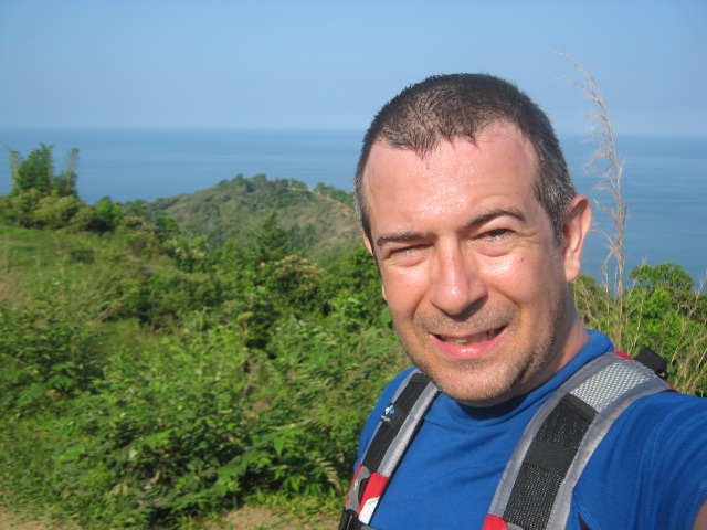 |
| The view is great but its a hell of a hot in the middle of the day |
Eventually after another 8-10km or so, the road forks again - you can actually go either way - left you'll pass some farmhouses and you can go for 15km more and get to Jaco beach in a more gentle fashion, and I suggest this road. Theother option is (like i did stupidly after asking the farmers wife in the house there which way was less difficult, she must have understood more difficult) to go right and what looks like your going nicely downhill....however halfway down the trail almost peters out to long grass (which isn't fun going steep downhill on) then you find yourself going down a track that is physically very difficult to stand up, you pretty much have to clamber, and then you find yourself in a quarry. It is in theory a shorter route (about 8km back to the road) but it probably takes at least twice as long, as you have to step down bit by bit, knowing every second that you may be about to hit a dead end of impenatrable jungle and have to climb back up again. After the quarry, its best to follow your nose out of there without getting shot by the (armed for some reason) guards there, and then the track becomes wider and you can gently follow it down to the original road, and eventually back out to Jaco. For some idiotic reason i got into the running mood about then, so i ran down the long road to the beach, just in time for sunset (6.15ish) and ran home that way.
As for Marathon De Sables training, i think that was my best day yet, but the bad news is that 1. i must have ran less than 50% of the distance, and climbed/walked/scrambled the rest and 2. I was aching like hell the next day, which doesnt bode well - i suppose im used to easy little beach runs not these mountains straining my calfs and knees and tendons. Interestingly the steep dowhill was a lot harder than the uphill, especially after a long and tiring day, so i think i'll spend the next week ahead of the race with a fair amount of hill running if i can to strenghten those muscles a bit and get them used to hills (as i beleive there are some in the race)
I think im as fit as im going to be due to my inherent laziness and lack of discipline, but i think i have my Chi-Running down ok now and ill try a 30-40km run tomorrow along the causeway here in Panama City and assuming its a breeze at a decent 5min-5.30km clip then i think ive done all i can do. The biggest issue ive had here is still running in the middle of the days humidity and heat, but hopefully its the humidity thats the problem (which wont be a problem in the desert!)


